


PHOTOS BY BELEN THOMAS
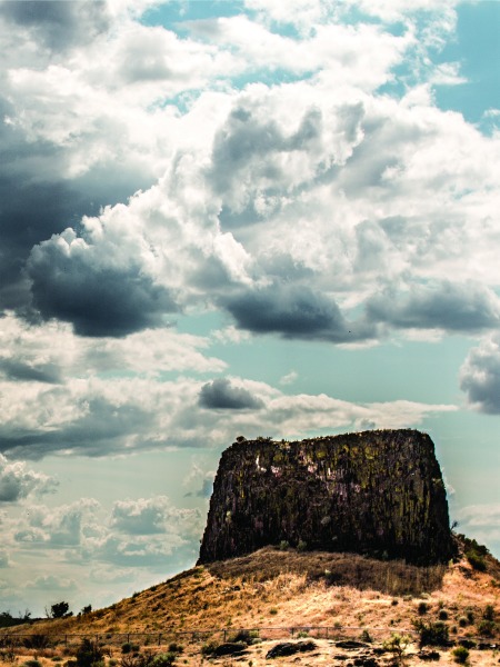
[quote style=”2″]Hat Rock Has Been Drawing Visitors Since 1805[/quote]
Paddling down the Columbia River on a clear and frosty day in 1805, William Clark saw a round rock, with a flat top and vertical sides.
The handsome rock stood seven stories above the surrounding landscape.
Struck by the sight, he noted an outcropping “resembling a hat” in his journal entry of Oct. 19.
On his hand-drawn map, he placed a dot and labeled it “Hat Rock.”
Hat Rock was the first distinctive landmark noted by the Lewis and Clark Expedition on its trip down the Columbia River. It’s one of few sites mentioned in the journals that aren’t under water today, according to the state parks service.
Clark’s precise description of Hat Rock wasn’t by chance – President Thomas Jefferson had asked Lewis and Clark to describe with “great pains and accuracy” the details of their Corps of Discovery expedition. Skilled in geography, Captain Clark made maps and drew illustrations that have been much admired through the ages.
On Oct. 19, after passing Hat Rock, the expedition passed through two miles of a “verry bad rapid” (later called Umatilla Rapids), spied a high mountain covered with snow (believed to be Mount Adams), noted dozens of Indian lodges along the river, and smoked and visited with the native tribes. Clark dined on a crane he had shot, and listened that night while two members of his party played the violin.
As they passed through the Umatilla country, the explorers enjoyed the “Pleasant . . . (and) level Smooth plains” and noted the distinctive look of the dark and dense rocks that dominated the river bluffs.
Those black rocks came from Columbia Basin basalt eruptions that flowed repeatedly over millions of years, “spreading pools of basaltic lava,” according to the state parks service. Then, the lava gradually cooled into layers of basalt, shrinking and cracking in vertical columns. Slow, even rates of cooling caused straight, wide columns, while rapid cooling resulted in a more jumbled look, the parks service said.
In recent geologic times, catastrophic Ice Age floods that swept through Wallula Gap between 15,000 and 13,000 years ago carved out Hat Rock and nearby Boat Rock to the east, as well as the rest of the present-day Columbia River Gorge. The building of McNary Dam created the 64-mile Lake Wallula that now fronts Hat Rock State Park.
Old maps show wagon trails from the mid-1800s near Hat Rock. In the 1950s, the state of Oregon first began acquiring land for the park, noting that a large, natural spring near the southern tip of an arm of Lake Wallula. It flowed about 25 cubic feet per second, enough water to supply the park and adjoining homes along the shore.
The first acquisition was 175 acres purchased from Charles and Eileen Kik for $5,000 in 1951. Two years later another tract of 191 acres was obtained from the Army Corps of Engineers under a lease agreement. Today, the 719-acre park receives more than a quarter-million day-use visitors each year.
Hat Rock State Park includes dozens of picnic tables, a large grassy area and a sand court for volleyball. A spring-fed pond for fishing is stocked with rainbow trout.
A boat ramp gives access to Lake Wallula, known for its walleye and sturgeon. The Hat Rock Trail ascends to the base of Hat Rock (which is fenced off) and offers close-up views of nature as it loops around the pond. Six interpretive displays tell about the area’s wildlife, past volcanic activity and visit by the Lewis and Clark Expedition.
Adjacent to the park are a general store, RV park, housing development and private boat club.
Those looking for a longer hike can take a short trail near the boat launch area that connects to the 10-mile Lewis and Clark Commemorative Trail along Lake Wallula. At the very least, take the short walk up to the bluff for a commanding view of the river.